🕓 2026/5/25
#Tourist Destination
Heavenly Vistas and the Path of Mountain Worship on the Tateyama Kurobe Alpine Route

Table of Contents
Introduction
At an altitude of 2,450 meters, a vast snowfield stretches before you, while the majestic peaks of the Northern Alps soar against a sapphire sky — the Tateyama Kurobe Alpine Route is a “Sky Corridor” that traverses the roof of Japan, connecting Toyama and Nagano prefectures through six types of mountain transportation. In 2026, marking the 55th anniversary of its full opening, new access improvements and the upcoming “Kurobe Unazuki Canyon Route” are drawing greater attention than ever. This article comprehensively covers the route’s history, highlights, and the latest visitor information.
In this guide, we present a multi-layered exploration of its charm — from a geological and geographical overview of its formation, through its history of mountain worship and civil engineering, to the breathtaking spots that continue to captivate visitors.
Overview of the Tateyama Kurobe Alpine Route
The Tateyama Kurobe Alpine Route is a mountain sightseeing route stretching approximately 37 kilometers across the Northern Alps (Hida Mountains), connecting Tateyama Station in Toyama Prefecture to Ogizawa Station in Nagano Prefecture. Using six types of transportation — cable car, highland bus, trolleybus, ropeway, funicular, and electric bus — visitors traverse the route from an elevation of about 475 meters at the starting point to a maximum altitude of 2,450 meters at Murodo, the highest point.
As one of Japan’s premier mountain tourism routes, it welcomes approximately one million visitors annually, including many from overseas, drawn by the stunning alpine scenery, rich natural environment, and historical significance as a site of mountain worship.
- Geography and Terrain
The Tateyama mountain range, the backbone of this route, is part of the Northern Alps and includes peaks exceeding 3,000 meters such as Mt. Oyama (3,003 m), Mt. Oniwa (2,999 m), and Mt. Tsurugidake (2,999 m). The dramatic terrain was shaped over tens of thousands of years by volcanic activity and glacial erosion, creating the Tateyama Caldera, deep valleys, and the distinctive U-shaped valleys characteristic of glaciated landscapes.
The route passes through dramatically different vegetation zones as altitude changes. From the lush sugi (Japanese cedar) forests at Bijodaira (977 m), through the subalpine conifer zone, to the alpine meadows and snow patches at Murodo (2,450 m), visitors can experience multiple ecological zones in a single day. The Midagahara wetland at 1,930 meters is registered under the Ramsar Convention and hosts approximately 3,000 pond depressions known as “Gaki-no-ta” (Demon’s Rice Paddies).
- The Snow Wall (Yuki-no-Otani)
The most iconic spectacle of the Alpine Route is the “Snow Wall” (Yuki-no-Otani), towering walls of snow that line the road near Murodo. Reaching heights of up to 20 meters in peak years, these snow corridors are created when snowplows carve through the massive snowdrifts that accumulate over winter. The walking route through the snow walls is open from mid-April to mid-June, allowing visitors to stroll between these towering white cliffs and feel the overwhelming power of nature.
The area around Murodo receives some of the heaviest snowfall in the world due to moisture-laden winds from the Sea of Japan colliding with the mountain barrier. This extreme snowfall is what makes the Snow Wall possible and also feeds the alpine lakes and streams that characterize the summer landscape.
- Murodo Plain
Murodo Plain, at 2,450 meters above sea level, is the highest point on the Alpine Route and home to Japan’s highest-elevation bus terminal. The area offers stunning views of the Tateyama mountain range and is the starting point for hikes to Mt. Oyama summit. Mikurigaike Pond, a volcanic crater lake with its distinctive cobalt blue waters, is one of the most photographed spots along the route. The easy 1-hour circular walking trail around the pond is suitable for visitors of all fitness levels.
Murodo is also one of the best places in Japan to spot the Japanese rock ptarmigan (raich), a special natural monument. These plump alpine birds are relatively unafraid of humans and can often be seen foraging near the walking trails, especially in early summer.
- Transportation System
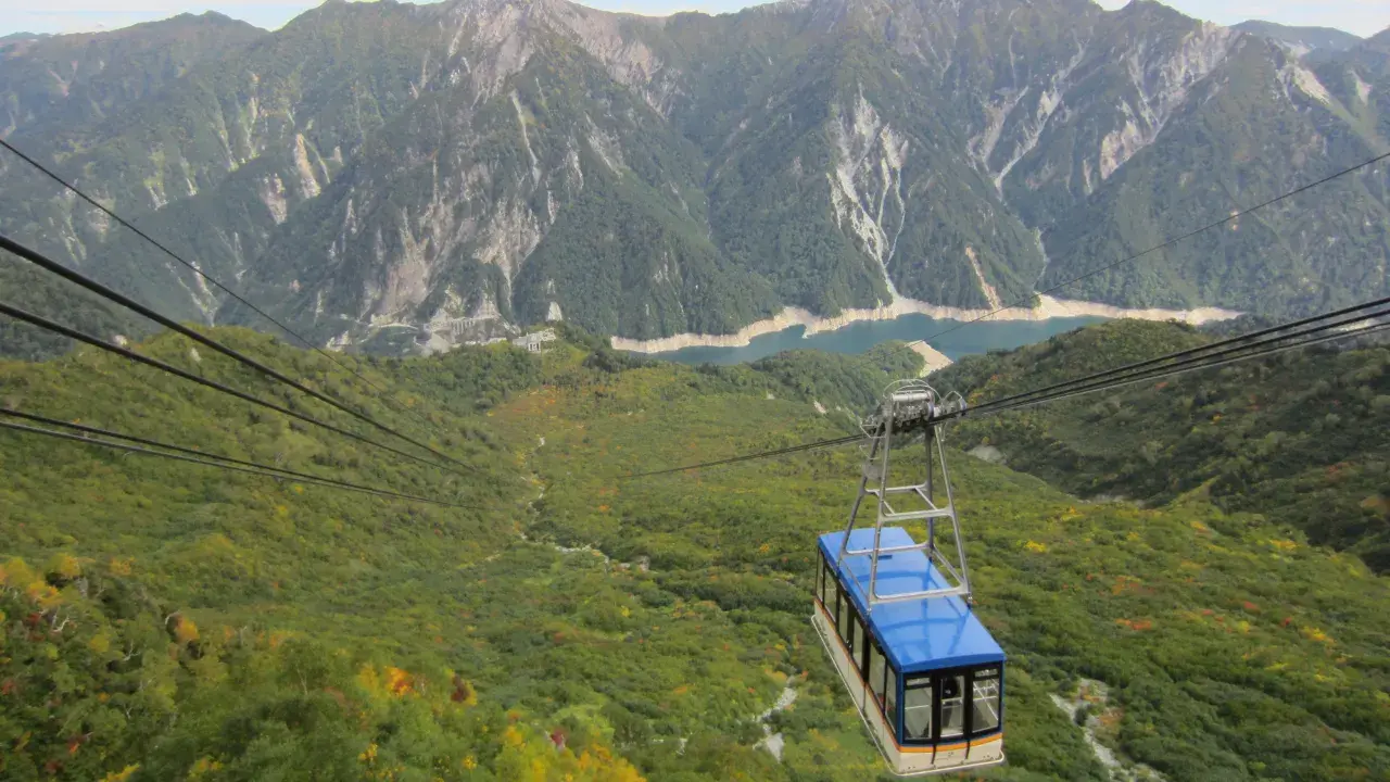
The Alpine Route’s transportation system is an engineering marvel in itself. Six different vehicles connect the route: the Tateyama Cable Car climbs steeply from Tateyama Station to Bijodaira; the Tateyama Highland Bus winds through alpine meadows to Murodo; the Tateyama Tunnel Trolleybus passes beneath Mt. Tateyama to Daikanbo; the Tateyama Ropeway — Japan’s longest unsupported span at 1.7 km — descends to Kurobedaira; the Kurobe Cable Car, Japan’s only fully underground funicular, connects to Kurobe Dam; and finally the Kanden Tunnel Electric Bus completes the journey to Ogizawa.
Private vehicles are prohibited on the route to protect the alpine environment, making these specialized vehicles the only way to traverse this mountain corridor. The entire journey from Tateyama to Ogizawa takes approximately 5-6 hours including transfers, though most visitors spend a full day with stops at various viewpoints.
- Visitor Information
[ Tateyama Kurobe Alpine Route Basic Information ]
| Item | Details |
|---|---|
| Route Name | Tateyama Kurobe Alpine Route |
| Location | Tateyama Town, Toyama Prefecture to Omachi City, Nagano Prefecture |
| Operating Period | Mid-April to late November (varies by year) |
| Major Highlights | Snow Wall (up to 20 m), Kurobe Dam (height 186 m), Murodo Plain |
| Nearest Transportation Hub | Toyama Station (Toyama side) / Shinano-Omachi Station (Nagano side) |
| Best Season | Snow Wall (Apr-Jun), Summer flowers (Jul-Aug), Autumn foliage (Sep-Oct) |
History of the Tateyama Kurobe Alpine Route
The Tateyama Kurobe Alpine Route’s story encompasses ancient mountain worship spanning over a millennium, a heroic dam construction project, and a pioneering mountain tourism route — a rich tapestry of faith, engineering, and nature interwoven across the ages.
Here we trace five turning points, from the origins of Tateyama mountain worship to the modern Alpine Route’s establishment and current developments.
1. Ancient Times: The Birth of Tateyama Mountain Worship
Tateyama has been revered as one of Japan’s “Three Sacred Mountains” (Sanreizan) alongside Mt. Fuji and Mt. Hakusan since ancient times. According to legend, the mountain was first opened for worship in 701 AD by Saeki-no-Ariyori, who was guided by a bear and a hawk — animals considered divine messengers. The Oyama Shrine at the summit became the center of Tateyama faith, and the concept of “Tateyama Mandala” — depicting the mountain as a Buddhist paradise and hell — spread throughout Japan during the medieval period.
2. 1956-1963: The Kurobe Dam Construction — A Monument to Human Determination
The construction of Kurobe Dam, Japan’s largest arch dam at 186 meters high, was one of the most challenging civil engineering projects in Japanese history. Built between 1956 and 1963 to meet the nation’s growing electricity demands during the postwar economic boom, the project employed over 10 million workers and tragically claimed 171 lives. The breakthrough excavation of the Kanden Tunnel through the treacherous Kurobe fault zone — dramatized in the 1968 novel and film “The Black Mountains” (Kurobe no Taiyo) — became a symbol of Japan’s postwar spirit of perseverance.
3. 1971: Full Opening of the Alpine Route
On June 1, 1971, the Tateyama Kurobe Alpine Route opened its full length to the public for the first time. This milestone connected the existing Kurobe Dam access tunnel with new cable cars, buses, and ropeways, creating a continuous mountain crossing route. The opening transformed what had been an area accessible only to experienced mountaineers into a destination that anyone could visit, democratizing access to Japan’s alpine scenery.
4. 2005-2024: Environmental Protection and Modernization
In 2005, the Midagahara Wetland was registered under the Ramsar Convention, recognizing its international importance as a high-altitude wetland ecosystem. This designation strengthened environmental protection measures along the route. In 2019, the diesel-powered trolleybuses on the Tateyama Tunnel route were replaced with electric buses, eliminating exhaust emissions in the tunnel. The ongoing conversion to environmentally friendly transportation reflects the route’s commitment to preserving the pristine alpine environment for future generations.
5. 2026: The 55th Anniversary and the Kurobe Unazuki Canyon Route
2026 marks the 55th anniversary of the Alpine Route’s full opening. The highly anticipated “Kurobe Unazuki Canyon Route,” connecting Kurobe Dam with Keyakidaira, is scheduled to begin full operation during 2026, creating a new tourism route that will reveal the previously inaccessible inner Kurobe Gorge to visitors for the first time.
Recommended Spots on the Tateyama Kurobe Alpine Route
The Tateyama Kurobe Alpine Route offers a spectacular variety of natural landscapes and historic sites. Below we introduce the major spots that every visitor should experience.
1. Snow Wall Walk (Yuki-no-Otani) at Murodo
The Snow Wall Walk is the Alpine Route’s most iconic experience, offering a 500-meter pedestrian path flanked by towering walls of snow up to 20 meters high. Open from mid-April through mid-June, this natural corridor is created each spring when snowplows clear the road through Murodo’s massive snowdrifts. The walk is flat and accessible, taking about 30 minutes round trip. For the best experience and smallest crowds, weekday mornings are recommended.
2. Daikanbo and the Tateyama Ropeway Area
Standing on the **”Cloud Terrace”** atop Daikanbo Station at 2,316 meters, you can gaze down at the emerald-green Lake Kurobe below and across to the rugged ridgelines of the Ushirotateyama mountain range including Mt. Harinoki and Mt. Subari. The terrace was renovated in 2024 with wooden benches and tables, and a takeout-only micro cafe has been added. Enjoying hand-dripped coffee in the crisp mountain air has become a popular “sky cafe” experience.
The Tateyama Ropeway connecting Daikanbo and Kurobedaira boasts Japan’s longest unsupported span (1.7 km), making the cabin itself a “moving observation deck.” Lake Kurobe is on the left side and the golden grass of Tambo-daira is on the right, so in summer the left window offers the best views, while in autumn the right side provides beautiful color compositions.
3. Kurobe Dam
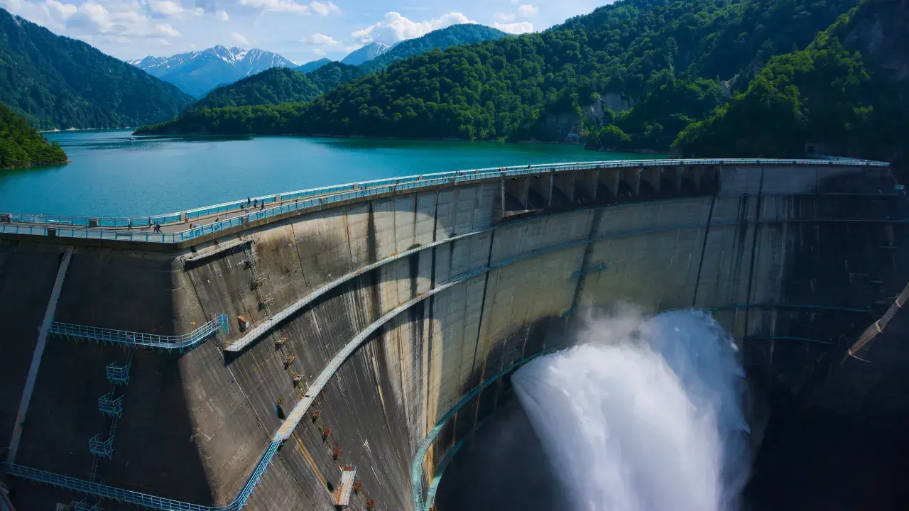
Standing 186 meters tall with a crest length of 492 meters, this is one of Japan’s largest arch dams. The tourist water discharge runs from June 26 to October 15, with a maximum flow of 15 cubic meters per second creating a spectacular spray that often produces rainbows. Discharge times vary by season, starting as early as 6:00 AM (shifting to 6:30/7:00 AM from July onward), so the best time to catch a rainbow is around 8 AM when sunlight hits at an angle.
The Rainbow Terrace at the center of the dam crest lets you feel the spray up close, and in summer the mist cooling effect is said to lower the perceived temperature by about 5 degrees Celsius. The dam-side rest house offers the famous Kurobe Dam Curry and limited-edition goods, and on the first day of water discharge, a commemorative “Discharge Day Dam Card” is distributed, drawing collectors who line up from early morning.
4. Bijodaira Primeval Forest
Bijodaira, at 977 meters elevation where the Tateyama Cable Car terminates, is a dense forest of ancient Tateyama cedar (over 1,000 years old), beech, and horse chestnut trees. The 1.4 km Bijosugi Course takes about 40 minutes round trip and allows visitors to view giant cedars selected for Japan’s “One Hundred Giant Trees of the Forest.”
May through June is peak birdwatching season with blue-and-white flycatchers and narcissus flycatchers singing, and from early October a tunnel of autumn foliage in yellow, orange, and red appears. The observation terrace atop the station sometimes offers simultaneous views of a sea of clouds and the Toyama Plain below — a hidden gem for experiencing the “boundary of the clouds.”
5. Midagahara Wetland
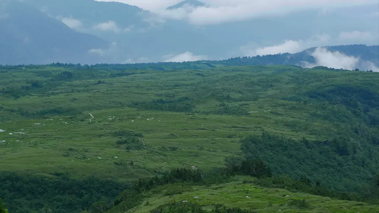
At 1,930 meters elevation, the **Midagahara Wetland** on this volcanic plateau was registered under the Ramsar Convention in 2005 and is one of Japan’s largest high-altitude moors. The approximately 3,000 small ponds, known as “Gaki-no-ta” (Demon’s Rice Paddies), create a distinctive patterned landscape.
From June through August, cotton grass, mountain avens, and bog bean bloom profusely, and by late September the entire area transforms into golden autumn grass. The boardwalk in front of the Midagahara Hotel covers a full circuit of 1.2 km (about 30 minutes), and early morning sea-of-clouds views and sunsets over the Tateyama Caldera are particularly spectacular.
6. Mt. Oyama Summit and Oyama Shrine Peak Sanctuary

The summit of Mt. Oyama (3,003 m), reached from Murodo in about 2 hours with an elevation gain of approximately 550 meters, is the principal peak of the Tateyama mountain range. The Oyama Shrine Peak Sanctuary at the summit opens its shrine office only from July 1 to September 30, during which visitors can receive goshuin (seal stamps) and purification blessings (1,000 yen offering). Outside this period, the doors are closed and only free prayer is possible, so those seeking a complete pilgrimage should note that it is limited to the summer climbing season.
From the summit, visitors can survey the Tateyama Caldera, Toyama Bay, and on lucky days, even the sunset over the Sea of Japan. The mid-September sunset in particular is known as the “Burning Blade” spectacle, when the ridgeline of the Northern Alps is dyed crimson. At night, the Milky Way arches directly overhead, and the extraordinary transparency at this altitude has made it a sacred spot for astrophotography.
7. Shomyo Falls (Side Route)
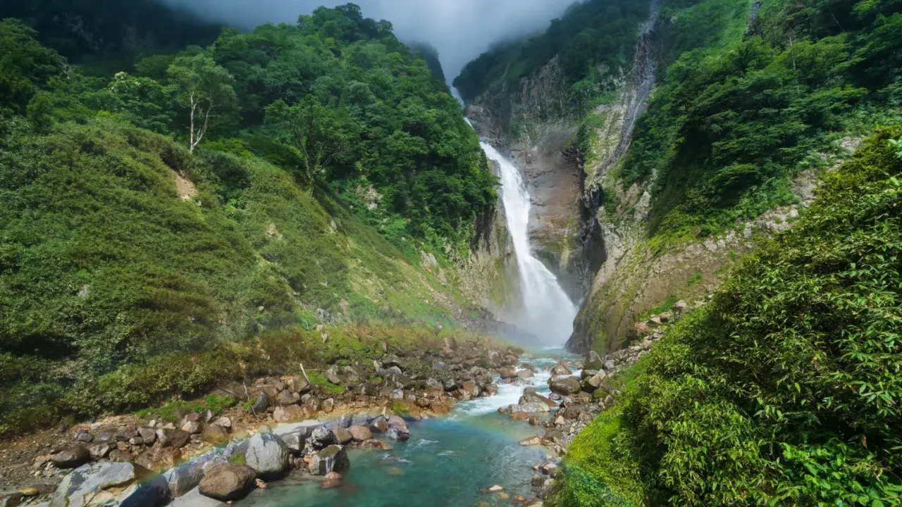
Accessible by shuttle bus from Tateyama Station (Shomyo Falls Exploration Bus) and a 30-minute walk, **Shomyo Falls** has a drop of 350 meters, making it the tallest waterfall in Japan. In years with heavy spring snowmelt, the phantom **Hannoki Falls (approximately 500 m drop)** appears alongside it, creating a thundering spectacle of twin waterfalls.
The Shomyodaira parking area to waterfall viewing platform trail is closed in winter, with the 2026 opening scheduled for late May. Gate hours are 6:00 AM to 7:00 PM in July-August and 7:00 AM to 6:00 PM otherwise, so plan accordingly for early morning photography or long-exposure shots.
[ Tips for Planning Your Trip ]
| Purpose | Best Spot | Best Season | Notes |
|---|---|---|---|
| Social Media Photos | Snow Wall | Late Apr – Mid May | Weekday mornings are less crowded. |
| Sky Hiking | Midagahara to Murodo | Jul – Sep | One-way hiking time approx. 3 hours. |
| Family-Friendly | Kurobe Dam Discharge | Jul – Aug | Tourist discharge runs rain or shine. |
| Advanced Trekking | Mt. Oyama Summit | Jul – Early Oct | Combining with camping at Raichozawa is convenient. |
2026 Latest Information
2026 marks the 55th anniversary of the Tateyama Kurobe Alpine Route’s full opening. A commemorative logo featuring a ptarmigan parent and chick has been unveiled, and various anniversary campaigns are being held. Additionally, the “Kurobe Unazuki Canyon Route” connecting Kurobe Dam and Keyakidaira is scheduled for full operation in 2026, attracting significant attention as a much-anticipated new tourism route.
Regarding access, a timetable revision by the Toyama Regional Railway on March 14, 2026 introduced new non-stop limited express services toward Tateyama, shortening travel time. Connections with the Hokuriku Shinkansen have also been strengthened. For tickets, the “WEB Ticket” reservation site has been significantly revamped, and advance online booking is strongly recommended. Please note that the Murodo Terminal Building is undergoing reinforcement work until November 2026, so be sure to check the official website for the latest information before visiting.
Summary
The Tateyama Kurobe Alpine Route is the crystallization of majestic nature carved out over thousands of years of volcanic activity and glaciation, combined with the passion of pioneers who opened this mountain transportation corridor. With improved access and comfort thanks to 2026 upgrades, now is the perfect time to experience this “Sky Corridor” with all five senses. While following rules and etiquette, please enjoy the emotional journey through the grand panorama of the Northern Alps.